UH Hilo researchers use drones to aid lava monitoring
The team used drones to do high-resolution mapping of different land forms to help Civil Defense pinpoint the areas of advancing lava during the Kīlauea eruption.

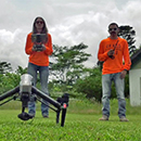
The team used drones to do high-resolution mapping of different land forms to help Civil Defense pinpoint the areas of advancing lava during the Kīlauea eruption.
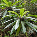
Deep in the Honouliuli Forest Reserve a sophisticated monitoring system is being administered by the Pacific Biosciences Research Center to observe Caly or cyanea calycina.
Professors, scientists and students are providing valuable expertise and resources to help officials assess hazards and decide how to respond.
UH researchers developed a collaborative approach to assessing the multiple values that different ecosystems in Hawaiʻi provide and how collaboration with stakeholders can help evaluate and compare the potential future uses of pastureland.

Field presents “Climate Change Impacts and Solutions: Finding the Accelerator Pedal” at the UH Mānoa.

UH Mānoa's Krisna Suryanata will spend six months in Indonesia sharing her conceptual tools in teaching and researching the political ecology of agriculture.

According to associate professor of geography Camilo Mora, the significance of this deadly heat will depend on the sensitivity of the human body to heat.
Students learn the scientific concepts behind climate change and then analyze current and future impacts, challenges and opportunities.

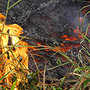
Researchers are using an unmanned aerial vehicle at one of the epicenters of the rapid ʻōhiʻa death infection to monitor the damage.

A UH Mānoa study projects a continued rise of lethal heat episodes if carbon gas emissions continue to rise.
