The U.S. Coast Guard recovered a drifting wave buoy deployed by the Pacific Islands Ocean Observing System (PacIOOS) 800 nautical miles (NM) offshore from its original location off Tanapag, Saipan, in December 2018. The buoy broke free from its mooring in 20- to 25-foot seas when Super Typhoon Yutu directly hit the Mariana Islands on October 25, 2018. Rough storm and ocean conditions did not favor a speedy recovery, allowing the buoy to drift west in the Philippine Sea.
PacIOOS, based at the University of Hawaiʻi at Mānoa School of Ocean and Earth Science and Technology, immediately notified the U.S. Coast Guard after the wave buoy departed. At the time, the U.S. Coast Guard was not able to assist with the retrieval of the drifting asset since all available units were focusing on comprehensive post-storm assessments and recovery efforts. Fortunately, all PacIOOS wave buoys are equipped with GPS, ensuring continuous monitoring and tracking of the buoy’s position.
Buoy retrieved and safely transported 46 days later
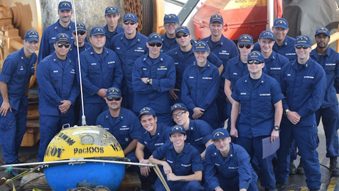
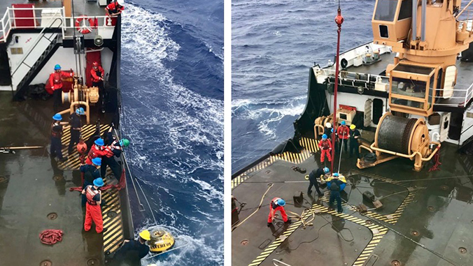
After 46 days, the buoy had drifted 920 statute miles (800 NM) offshore making recovery extremely unlikely. The crew of U.S. Coast Guard Cutter Sequoia, stationed in Guam, was patrolling the high seas, bringing the ship to “the neighborhood” of the buoy. Knowing the wave buoy and its associated data are extremely important to a variety of stakeholders, the crew temporarily diverted from operations to retrieve the buoy. Sequoia is an ocean-going buoy tender and regularly services large buoys and other aids to navigation. Despite the challenging conditions of 8 to 10-foot seas and 28–35 mph winds, the crew was able to retrieve the wave buoy using the installed crane and hydraulic equipment, and safely transported the buoy back to Guam.
Crucial data for ocean users
PacIOOS maintains a network of 15 wave buoys, three of which are located within the Mariana Islands (off Ipan and Ritidian Point, Guam, and off Tanapag, Saipan). It is one of 11 regional associations of the U.S. Integrated Ocean Observing System.
All wave buoys provide real-time information on significant wave height, period and direction, as well as sea surface temperature. The freely available data are crucial for federal and local agencies, as well as for commercial and recreational ocean users. Real-time ocean observations are limited throughout the region, magnifying the value and need of the PacIOOS wave buoys.
“We rely on a multitude of satellite data for issuing forecasts and advisories, but satellites only indirectly determine important ocean parameters. The PacIOOS wave buoys are our only routine source of directly measured nearshore ocean observations, allowing us to calibrate the satellite-derived ocean data,” said Roger Edson, National Weather Service Forecast Office Guam science and operations officer. “Waves can change dramatically in time and location so it is vital to have buoys in good strategic locations around the islands in order to be able to see approaches from all directions and ensure a 360 degree view.”
Read the full story on the PacIOOS website.
—By Fiona Langenberger