Rainfall estimations on Oʻahu can be more accurate by combining Hawaiʻi’s two main types of rainfall observations, radar and rain gauge, according to a study by University of Hawaiʻi at Mānoa researchers. Current observations are based on one or the other, where specific weather stations are checked (rain gauge), or weather radars are observed to view patterns. The study is an effort to better understand Hawaiʻi’s complex weather patterns and hydrological consequences.
Like most of the world, Hawaiʻi is experiencing more extreme weather, yet often lacks adequate data. By bridging the gap between radar and gauge data, experts can now gain a better understanding of the complex rainfall patterns in mountainous tropical areas across the state, as well as the inherent uncertainties associated with various storm types and structures when simulating streamflow.
The new dataset, which stemmed from combining radar and rain gauge data, also creates better synergy across disciplines. Meteorologists and hydrologists can deepen their understanding, leading to more accurate assessments of flash flood risks, urban planners can test their plans and products against rainfall data, and emergency responders can be more prepared for natural disasters.
“The significance of this research is not only for its immediate benefit to resource managers, weather forecasters and emergency managers, but also for its potential to jumpstart new scientific advances in atmospheric and water sciences,” said Thomas Giambelluca, director of the UH Mānoa Water Resources Research Center.
The study, “Deriving Gridded Hourly Rainfall on Oʻahu by Combining Gauge and Radar Rainfall,” was published in the Journal of Hydrometeorology. It was conducted by Tsang Stream Lab in the College of Tropical Agriculture and Human Resources’ Department of Natural Resources and Environmental Management and the Nugent Research Group in the Department of Atmospheric Sciences.
Better preparation, resilience
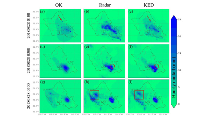
Radar rainfall observation provides rain rate over a large spatial area within a specific time frame (~every five minutes) but struggles with accuracy, while rain gauges provide “ground truth” values (information from direct observation and measurement), but only measures at limited point locations.
Recognizing the need to combine these two observation types to collect more accurate data, the UH Mānoa researchers built off of a previous effort that compiled hourly gauge and radar data throughout the state of Hawaiʻi (hourly rainfall data available here), and merged the two main types of rainfall observations to create a detailed hourly gridded rainfall dataset for Oʻahu. This incorporation of two data sources is also known as kriging with external drift (KED), allowing the researchers to refine rainfall values estimated only by a single instrument.
“With this developed and validated KED method, we are advancing Hawaiʻi’s capacity to better prepare and build resilience when facing climate extremes,” said Yinphan Tsang, co-author of the study and principal investigator of the Tsang Stream Lab.
This research offers valuable insights into the performance of the KED method across various storm types, such as tropical cyclones, cold fronts, upper-level troughs and Kona lows, to accurately estimate rainfall in these scenarios for flood forecasting and impact applications.
“The validated KED hourly rainfall dataset is an especially valuable tool for ongoing research on extreme weather impacts and water resources in Hawaiʻi,” said Giambelluca.