
The Pacific Islands Ocean Observing System (PacIOOS) based at the University of Hawaiʻi at Mānoa is helping to enhance disaster and climate resilience in the Republic of Palau. Palau experiences frequent natural hazards, and the impact of climate change and sea-level rise has become a priority issue. Those extreme weather and climatic events often result in disruption of economic activity, and loss of people’s livelihoods.
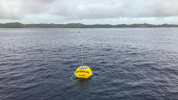
A new Waverider buoy was deployed in Palau through an international collaboration. The buoy provides data—wave height, period and direction; surface current direction and speed; sea surface temperature and air temperature—will enhance disaster and climate resilience in the Republic of Palau. This wave buoy, the only Waverider in Palau, is located on the East side of the island of Babeldaob, about 1.4 miles offshore of Ngaraard State.
This effort is led by the Palau National Weather Service Office (NWSO) through the United Nations Development Programme (UNDP)’s Enhancing Disaster and Climate Resilience (EDCR) project, with PacIOOS serving as the technical partner.

“PacIOOS strives to provide timely, reliable, and accurate ocean information to enhance safety and resilience,” said Melissa Iwamoto, PacIOOS director. “As such, we are honored to collaborate with Palau NWSO and all the partners on this effort, and we are dedicated to enhancing the capacity in Palau to maintain these valuable ocean instruments to serve user needs.”
See more stories involving PacIOOS.
PacIOOS will continue to provide technical support as needed in the coming years. The buoy will also provide essential validation points for future development of a high resolution wave model for the island nation.
In addition to being a central user of the data, Palau NWSO will steward the Waverider buoy to ensure its ongoing operations and maintenance. Based on the experience gained from this project, Palau NWSO plans to expand the national wave buoy in the future with Green Climate Fund support managed through the UN Environmental Programme.
“Accurate and reliable wave and current data provide critical information to our weather forecasters, other agency officials, fishers, mariners and many other recreational and commercial ocean users to better understand prevailing ocean conditions and to make safe decisions,” said Maria Ngemaes, Palau NWSO meteorologist-in-charge. “The new wave buoy will help us to validate and/or compare satellite and altimeter derived information on the same variables that the buoy measures. It will also help us to monitor the conditions of the ocean in the event of severe weather and climate variability phenomenon, such as the extremes of ENSO: La Niña and El Niño, the monsoon, tropical cyclones, tropical disturbances and shear lines that dip near and north of Palau, as well as sea level characteristics.”
Supporting local efforts, future advances
Currently, PacIOOS also provides a six-day high sea level forecast for Malakal, Palau. This is the first time PacIOOS has been a part of deploying and supporting a wave buoy in Palau.
While in Palau for the wave buoy deployment, PacIOOS wave buoy specialist Andreia Queima gave presentations to local agencies, organizations and communities that are interested to learn more about the buoy, the data it provides and how to access and use the data. She also worked with the Palau NWSO team to implement protocols to maintain the wave buoy.
For data access, visit the PacIOOS Palau Wave Buoy page and the Coastal Data Information Program website. For more information, see the School of Ocean and Earth Science and Technology website.
