

The most comprehensive survey of near-shore ocean water quality around the main Hawaiian Islands has been completed by a team from the University of Hawaiʻi at Mānoa using Saildrone Explorers, autonomous sailing vehicles loaded with scientific sensors. A variety of factors for water quality were monitored and the findings are expected to help state leaders make informed decisions on policies to protect Hawaiʻi’s coasts and prepare the state for climate change impacts.
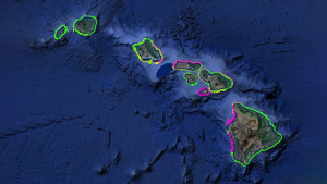
Three saildrones surveyed the Hawaiian Islands from April 6 to November 27. The goal of the mission was to collect high-resolution surface water quality data around Hawaiʻi Island, Maui, Lānaʻi, Molokaʻi, Kahoʻolawe, Oʻahu, Kauaʻi and Niʻihau. The saildrones sailed a zig-zag pattern, surveying each island and covering more than 20,000 nautical miles. Maui and Hawaiʻi Island were surveyed twice, six months apart, to help provide insights into potential seasonal patterns in ocean chemistry.
“Given the length and complexity of Hawaiʻi’s coastal waters, this type of study would not have been possible a few years ago,” said Christopher Sabine, UH Mānoa interim vice provost for research and scholarship and principal investigator for the project. “Technology has opened new opportunities to explore our oceans and understand how they are changing in new and exciting ways.”
The mission gathered well over a hundred thousand essential water quality measurements, including temperature, salinity, dissolved oxygen, chlorophyll, turbidity, pH and CO2 levels in both the water and air. These data are crucial for understanding the natural and human-driven patterns of water chemistry and assessing the impact of climate change and ocean acidification on marine resources.
“This new data covers more area around the state than we’ve previously had before, which will give us a better understanding of these patterns over our coastline area,” said Amy Markel, UH Mānoa oceanography PhD student on the project.
Related UH News stories
- Saildrones to navigate Hawaiʻi waters for critical UH research, April 2, 2023
- Saildrones, buoys work together to monitor Hawaiʻi waters, June 15, 2023
Mitigating climate change

This mission will serve as a foundation for evaluating the patterns of water chemistry surrounding the Hawaiian Islands, which is vital for assessing and mitigating the effects of climate change and ocean acidification on marine ecosystems, including coral reefs.
“These data will allow us to make informed decisions on how best to manage our resources, rather than relying on imperfect models or outdated notions that the natural environment is in a steady state,” said Sabine.
This effort was a significant step toward fulfilling the objectives outlined in the State of Hawaiʻi Ocean Acidification Action Plan, published in 2021. The plan emphasizes the need for increased scientific understanding of ocean acidification in the region to build adaptation and resilience into coastal communities.
Now that the mission is complete, researchers will start to analyze the diagnostic data the saildrones collected for a more comprehensive analysis of data quality. They anticipate that the finalized data will be of the highest quality and provide valuable insights into the water quality patterns associated with each island and across the state at a never before possible resolution.
This groundbreaking mission marks a significant advancement in oceanographic research, providing timely data that will contribute to informed decision-making and sustainable resource management in the face of climate change.
