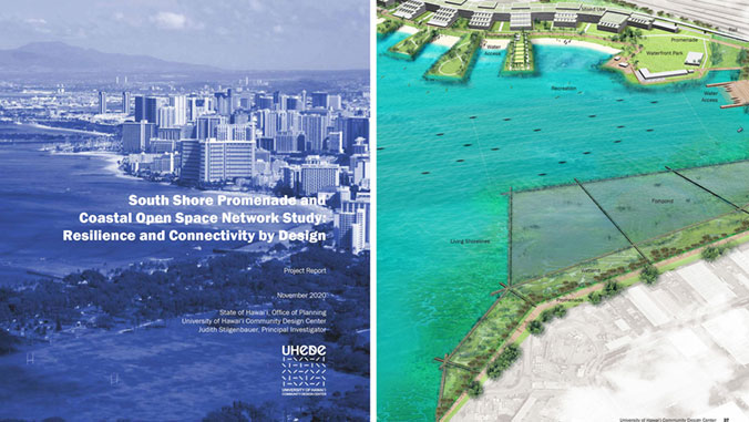
A visionary educational tool aimed at fostering dialogue about future planning along the south shore of urban Honolulu, which stretches from Diamond Head to Pearl Harbor, is the result of a two-year, state-funded applied research, analysis and proof-of-concept design project by the University of Hawaiʻi Community Design Center.
The completed “South Shore Promenade and Coastal Open Space Network Study: Resilience and Connectivity by Design” (PDF) project intends to further the contemporary local and global discourse on climate-resilient, adaptive urban waterfront development in tropical island settings. The work visualizes potential long-term sea-level rise scenarios and speculative, nature-based living shoreline design solutions.
“Bringing the South Shore project to its conclusion has felt great because we are proud of the results and happy to disseminate them more broadly!” said Judith Stilgenbauer, principal investigator of the project and professor of landscape architecture in the School of Architecture. “In contrast to many scientific sea-level rise and climate-change studies, which often paint doomsday scenarios, our project highlights opportunities intrinsic to an inevitable need to plan for the adaptation of our coastal urban fabric throughout the remainder of the century.”
Embrace coastal flooding
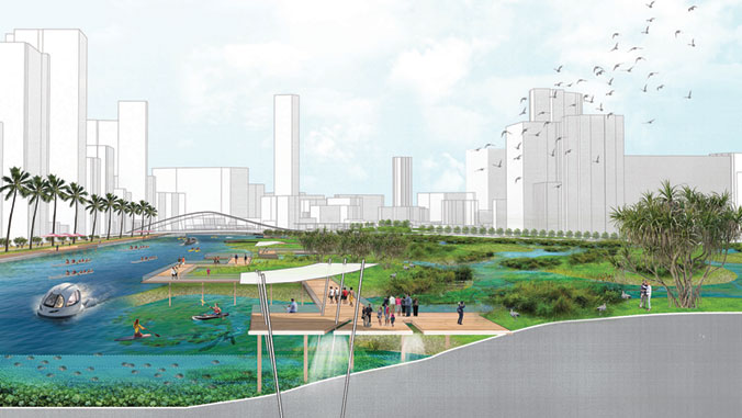
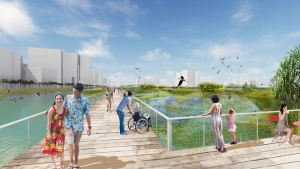
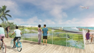
By investigating past, present and planned shoreline conditions in urban Honolulu, this study advocates for the anticipation of climate-crisis challenges through innovative planning and ecological design that embraces dynamic conditions, such as coastal flooding, rather than preventing them—all while taking inspiration from traditional Native Hawaiian biocultural land-water practices.
“This is critically important work that highlights the vast potential for adapting to sea-level rise,” said Chip Fletcher, associate dean and professor in UH Mānoa’s School of Ocean and Earth Science and Technology (SOEST). “The fact-based land-use analysis combined with the creative design depicting flooded landscapes, frees the viewer’s imagination to consider a future for Hawaiʻi in which our communities live with water, rather than fighting it. I will be referring to Judith Stilgenbauer’s work for years to come as it is a source of many solutions that we need to implement on our journey to building climate change resilience.”
This work is an example of UH Mānoa’s goal of Building a Sustainable and Resilient Campus Environment: Within the Global Sustainability and Climate Resilience Movement (PDF), one of four goals identified in the 2015–25 Strategic Plan (PDF), updated in December 2020.
Leveraging sea-level rise research
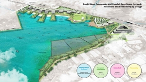
The project’s four guiding principles, which form the basis for the structure of the research and carry throughout the multi-scalar planning and design proposals—balanced in mutually beneficial ways—include: climate-change resilience, ecosystem performance, connectivity and placemaking.
“Stilgenbauer’s work leverages the sea-level rise modeling that researchers in SOEST produced in 2018,” said Fletcher. “Our models of flooding depict the footprint of sea-level rise impacts this century. It has always been our goal that experts in other disciplines would build on our products, which is exactly what this project does. This is the type of interdisciplinary thinking that needs to be at the heart of solutions to protect our communities in the face of a more dangerous climate.”
For any questions or inquiries regarding the South Shore project, please email Stilgenbauer at jstilg@hawaii.edu.