
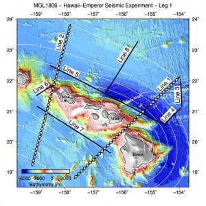
An international team of researchers, including several from the School of Ocean and Earth Science and Technology (SOEST) at the University of Hawaiʻi at Mānoa, returned from a successful 41-day research cruise to investigate the geology of the Hawaiian Island chain. Aboard the research vessel Langseth, operated by Lamont Doherty Earth Observatory, the scientists conducted seismic, gravity, magnetic and sonar surveys of the Hawaiian Island chain to assess volcanic construction and other geological aspects of the Hawaiian ridge.
The Hawaiian-Emperor Seamount Chain is the most well-known example on Earth of hotspot magmatism, where volcanoes form above a hot region in the mantle, far from the boundaries between tectonic plates where most earthquakes and volcanoes are concentrated. The chain of islands developed as the Pacific Plate moved slowly northwestward over the mantle hotspot (at a rate of approximately 30 miles per million years).
Today, Hawaiʻi Island is the most volcanically active, as dramatically shown by recent eruptions and earthquakes, and the islands to the northwest are successively older.
“Many questions remain about the fundamental earth processes that create the volcanoes of the Hawaiian-Emperor chain and elsewhere, and how the enormous mass of these volcanoes is supported by the oceanic plates below them,” said Robert Dunn, earth sciences professor and co-chief scientist on the expedition. “With this study, we obtained critical information about the volume and composition of new crust formed from hot spot magmatism, how it varies along the island chain, and how the tectonic plate deforms in response to the weight of the volcanoes.”
As each volcanic island in the chain grew, the oceanic plate beneath warped under the weight of the new volcano, creating a trough of deeper water around the chain. After volcanic activity ceased, each island started to erode. Older islands are typically smaller due to longer exposure to erosion. A dramatic aspect of island erosion is massive submarine landslides that have scattered rubble across the neighboring ocean floor. Some of these are thought to have generated large pre-historical tsunamis.
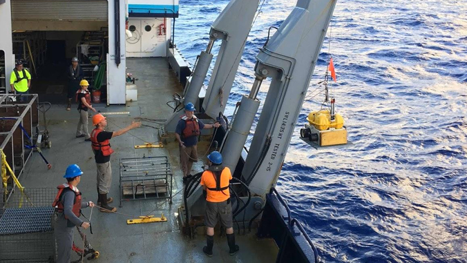
To look into the past, the research team, including SOEST earth sciences graduate students Charu Lata and Nina Nakrong and led by chief scientist Donna Shillington with Lamont-Doherty Earth Observatory of Columbia University, performed seismic surveys. During these surveys, the team emitted a pulse of sound waves from a controlled sound source and hydrophones acquired recordings of seismic energy that traveled into the earth, bounced off of rock layers below the seafloor, and returned to the sea surface. At the completion of the cruise, the team had collected nearly three terabytes of geophysical data. Combined, these data will allow the researchers to image geologic features as deep as 30 miles below the seafloor.
In addition to understanding the geologic history of the chain, the study will provide a more comprehensive assessment of geohazards for the Hawaiian Island region. Seismic surveys provide images of faults within the volcanic edifice and in the surrounding oceanic crust that could be used to evaluate seismic, tsunami and submarine landslide hazards.
Read more about the research at the expedition blog.
—By Marcie Grabowski
