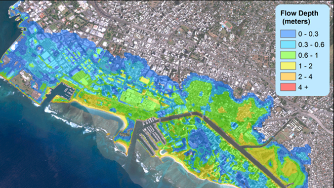
As the climate changes over the coming decades, the northward shift of hurricanes toward the Hawaiian Islands will increase the chance of landfall and pose severe flood risks to populations and infrastructure along the coast and further inland, says a recent study led by University of Hawaiʻi at Mānoa researchers at the School of Ocean and Earth Science and Technology (SOEST).
Tropical cyclones are usually weakened or deflected to the south when approaching the Hawaiian Islands, due to the high-pressure system to the northeast, strong wind shear and relatively low sea-surface temperature in surrounding waters.
But by synthesizing information from computer models for climate change, hurricane formation and intensity, storm surge and waves, lead author Ning Li, ocean wave model systems specialist in the Department of Ocean and Resources Engineering (ORE) at SOEST, and co-authors estimated future vulnerability to combined effects of sea-level rise and closer hurricane approach.
Assessing impacts of critical storms
“Of the nearly 2,500 future scenarios in our study, we selected 24 critical storm events that track near the islands to assess the probability of coastal flooding and created detailed flood maps with 100-, 200- and 500-year return periods,” said Li. “With high tide and the projected sea-level rise, the modeling results from a direct landfall of an Iniki-like hurricane on the south shore of Oʻahu showed extensive inundation of downtown Honolulu and Waikīkī. Other hurricanes passing near Oʻahu can also produce severe surge and high surf, causing coastal flooding.”
“The findings of our study were not a surprise,” added Kwok Fai Cheung, senior author on the study and professor in ORE. “Our recent experience with increasing number of storms tracking closer to the islands—Hurricane Guillermo in 2015, Hurricanes Celia, Darby and Lester in 2016, and Hurricanes Lane and Olivia in 2018—has already confirmed the change of hurricane patterns. The damage caused by Hurricanes Lane and Olivia underscores the importance and urgency of coastal storm hazards mitigation. This research should draw attention from state and federal agencies.”
Planning for the future
Coastal infrastructures and buildings planned or designed today will generally have a service life, that is, a period of time during which they are useful, through the end of 21st century. This study has shown climate change can potentially increase the severity of natural hazards within that time period, thereby reducing the reliability or safety of structures in the future.
“The inundation maps from this study will help assess the types of buildings and structures in the areas of Honolulu that would be exposed to increased flood risks,”said Li. “This has significant implications for engineering practice and land-use planning. If climate change effects are factored into design requirements through new regulations, an economic incentive is created for responding to climate change in planning, siting and construction of structures. This investment in increased resilience will offset the economic consequences of inadequate performance, loss due to damage, loss of marketability or even failures of safety.”
Cheung said, “We would like to seek opportunities to implement this approach in other strategic locations and extend the inundation mapping from urban Honolulu to other populated coastal communities.”
—By Marcie Grabowski

