

The first comprehensive map documenting the relative impact of human activities and natural events in slowing reef recovery after extreme coral bleaching caused by rising water temperatures in Hawaiʻi has been produced by an interdisciplinary group of researchers with University of Hawaiʻi ties.
The study, a large, multi-institution collaboration between Stanford University, UH, Stockholm Resilience Center, NOAA and others, synthesized 10 years of datasets from university and government sources across many factors for the first time to get a big-picture perspective on reef health and regional impacts. It provides a foundation for further research and informs policies to protect coral reefs.
The researchers from the collaborative Ocean Tipping Points project reviewed the data to gauge how a broad suite of factors, such as sedimentation, development and fishing, influence coral reef health across the main Hawaiian Islands.
The study appears in PLOS One and reveals variations in what was inhibiting reef recovery across the islands. On the densely populated island of Oʻahu, for example, the dominant stressors were human activities, such as fishing and loss of natural habitat to coastal development. Sedimentation and nutrient runoff were dominant forces on less populated islands.
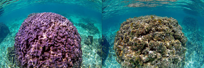
“When we jumped into the water in West Hawaiʻi, over half of the coral reef was dead. These are some of Hawaiʻi’s most vibrant coral reefs, so we were heartbroken—and determined to better understand how reef ecosystems could be more resilient in the future,” said the paper’s lead author, Lisa Wedding, a research associate at Stanford University’s Center for Ocean Solutions and graduate of
A big step forward to protect coral reefs

“This area of research has been a long-term need for coral reef conservation and management,” said co-author Joey Lecky, a NOAA GIS analyst who analyzed human drivers of change in the main Hawaiian Islands as part of his graduate work at
The research team’s findings highlight the importance of tailoring strategies based on location to effectively address local impacts. “These layers are being actively used in the ongoing state effort to meet Gov. David Ige’s 30×30 goal—protecting 30 percent of the nearshore by 2030—announced at the World Conservation Conference here in 2016,” noted Kirsten Oleson, Lecky’s advisor in the Department of Natural Resources and Environmental Management and a contributing author.
Coral reef data available online
Data created by this mapping study are available for free at the Pacific Islands Ocean Observing System website, where scientists, managers and members of the public can explore and further analyze what drives variation on coral reefs. Users can download data layers in various formats and explore all layers in an interactive map viewer.
For more, read the full story on the College of Tropical Agriculture and Human Resources website.
