HavoNet
Two field sites are located within Hawai‘i Volcanoes National Park (HavoNet) representing native forest and a forest invaded by an alien tree species, both within the cloud zone on the …

Two field sites are located within Hawai‘i Volcanoes National Park (HavoNet) representing native forest and a forest invaded by an alien tree species, both within the cloud zone on the …
Remote Automated Weather Stations (RAWS) are weather stations set up on tripods, and they look like little “Lunar Landers.” The data collected from these stations are used in numerous applications, …

CraterNet consists of 13 weather stations located in Haleakalā crater (a large erosional depression near the summit) as part of an effort to monitor endemic plant and insect species at …

Percent area drought time series (2000–2012) for the State of Hawai‘i for: (a) monthly aggregated U.S. Drought Monitor; and (b) gridded SPI-3 converted to USDM categories. Click here to read …

Reduced rainfall from meteorological drought can have direct effects on social-ecological systems; the most obvious consequence is reduced runoff and streamflow. Streams provide important ecological services on tropical islands, including …

The Hawai’i Permanent Plot Network (HIPPNET) was initiated in 2007 by faculty and research ecologists at the University of Hawaii, USDA Forest Service, and UCLA to investigate forest dynamics across …

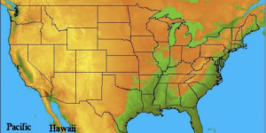
This research explores the relationship between 4-types of atmospheric disturbances and their contributions to daily rainfall on O‘ahu Hawai‘i. On average, atmospheric disturbances account for 29% of the annual and 41% of the seasonal (Nov – April) rainfall on O‘ahu Hawai‘i. Cold, fronts are the most common disturbance type, and fronts that cross over the island are shown to bring significantly more rainfall than the fronts that track to the north of the Island chain…

The Haleakalā Climate Network consists of two transects of climate stations along the leeward and windward slopes of Haleakalā Volcano, Maui Island, Hawai‘i. The upper elevation stations are within Haleakalā National Park. HaleNet was established in 1988-90 on the relatively dry west-northwest facing (leeward) slope. The first stations were established in June 1988 at elevations of 960, 1640, and 2120 m…
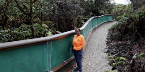
Contributed by John DeLay Monitoring the current endangered snail population and the new snail enclosure at the summit built in anticipation of climate change and the other using AI to detect …
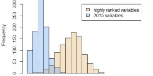
An exploratory analysis found that atmospheric predictor variables selected through statistical methods can lead to more accurate rainfall projections when compared to the previous predictor set used in statistical downscaling for rainfall projections in Hawaiʻi. This figure shows the skill of a linear model in projecting rainfall…