
This page will cover how to use the FCC National Broadband Map to determine eligibility for the Broadband Equity Access and Deployment (BEAD) Program. Click to learn more about the BEAD Program. Learn more (link opens in a new tab)
Post Date: Aug 1, 2023
Overview
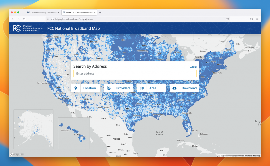
What is the FCC National Broadband Map?
- The FCC National Broadband Map is meant to reflect all the locations where the Internet can be installed in the USA.
- The FCC Broadband Map also provides information on which Internet technologies are available to locations by Internet service providers.
- The FCC Broadband Map is where people can input corrections to information on the FCC’s map.
Why use the FCC Broadband Map?
Simply put: you deserve access to high-speed and reliable internet. Having the FCC Broadband Map accurately reflect your current internet situation will enable the University of Hawaii to better identify locations needing internet access and eventually build infrastructure for those locations in need. You can be a part of helping the State of Hawaii to bridge the digital divide and bring high-speed Internet to all people of Hawaii.
Before you start using the Map
Before you start, it is important to understand some terms found on the map.
Broadband Type
Fixed Broadband – Internet that comes via technologies such as cable, fiber, or copper
Mobile Broadband – Internet that comes via cell phone technologies such as 3G, 4G, or 5G
Mass-market Broadband – Internet that is commercially available through an Internet service provider such as, but not limited to, Hawaiian Telcom or Spectrum
Broadband Status
Served – This status means that for the technologies and speed in your current selection on the broadband map, there is one or more Internet service provider that is able to provide your selected technologies and at the selected speeds.
In short, a “served” status indicates you have access to the selected technologies and speeds
Not Served – This means that for the technologies and speed in your current selection on the broadband map, no Internet service providers can provide your selected technologies and the selected speeds.
In short, a “not served” status indicates you do not have access to the selected technologies and speeds.
Building Type
The category that best describes how the building is used
- Community Anchor Institution (CAI) – An entity such as a school, library, health clinic, health center, hospital or medical provider, public safety entity, institution of higher education, public housing organization, or community support organization that facilitates the greater use of broadband service by vulnerable populations, including, but not limited to, low-income individuals, unemployed, children, the incarcerated, and aged individuals [60 years and above]. NTIA FAQ Document Link (Scroll to Section 1.7)
In short, a community anchor institution is a location that is generally considered a public institution, such as a public school, public library, police station, fire station, hospital, etc.
- Group Quarters (GQ) – Group quarters are defined as places where people live or stay in a group living arrangement owned or managed by an organization providing housing and/or services for the residents.
GQs differ from typical household living arrangements because the people living in them are usually not related to one another. GQs include such places as college residence halls, residential treatment centers, skilled nursing facilities, group homes, military barracks, prisons, and worker dormitories.
Source: https://www.census.gov/newsroom/blogs/random-samplings/2021/03/2020-census-group-quarters.html
- Enterprise – Larger business with many locations and a private phone network
- Unit Count – The estimated number of unit(s) within the location. In the case of Community Anchor Institutions and Group Quarters, the unit count is the count of CAI or Group Quarters units in the structure.
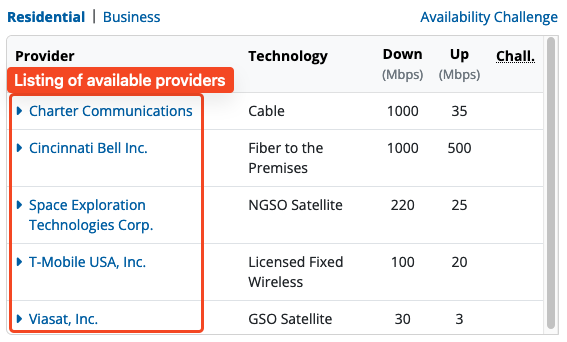
- Provider – Internet Service Provider
- Charter Communications Inc. = Spectrum
- Cincinnati Bell Inc. = Hawaiian Telcom
- Hawaii Dialogix Telecom LLC = Xiber Hawaii
- Hughes Network Systems LLC = HughesNet
- NetFortris Acquisition Co., Inc. = NetFortris
- Space Exploration Technologies Corp. = SpaceX Starlink
Internet Speed
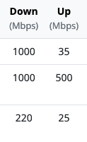
Down – download speed. Download is when you are receiving data. This is the maximum advertised download speed.
Up – upload speed. Upload is when you are sending data. This is the maximum advertised upload speed.
Mbps – megabits per second. The speed at which data is transmitted. The higher the number, the faster the speed.
How to determine your broadband status with the FCC Map
1. Go to https://broadbandmap.fcc.gov/home (Link opens in a new tab)
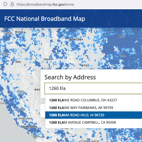
2. Start typing your address into the search bar. As you type, your address may appear in the drop-down. Click on the address matching as close as possible.
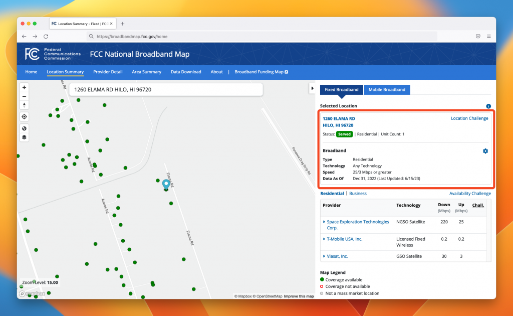
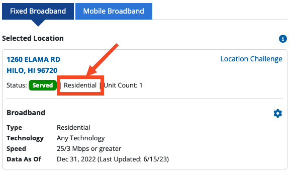
3. On the right side of the screen, next to “Status,” note the building type. In the screenshot below, the building type is “Residential”
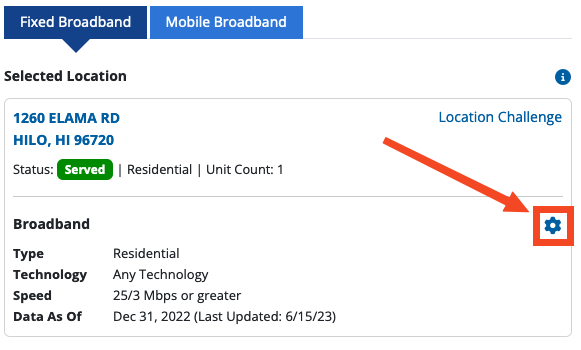
4. Click on the “gear” icon to bring up the map filter settings
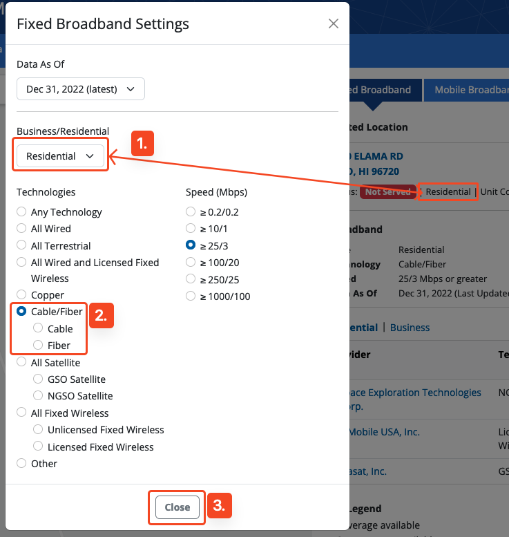
5. Use the map filter settings to determine if your location is serviceable by certain technologies. For BEAD eligibility, select “Cable/Fiber”
- Check that the dropdown matches the building type.
- Use the “Technologies” buttons to select the technology to filter. The image below shows Cable/Fiber technology being selected.
- Close the pop-up.
Note if the building type says “Business and Residential,” use “Residential.”
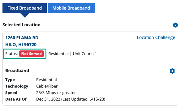
6. You should now see the status of the address reflect the technology and speed selected. In the screenshot below, this address is “Not Served” because it lacks access to cable and fiber internet technology at this address with 25 Mbps download and 3 Mbps upload speeds.
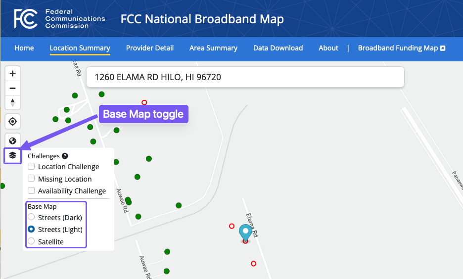
7. Optional: Use the left side layer tool to toggle between different base map types to help with viewing different map styles
What to do if your broadband status is “Served”
If your status after following the steps above is “Served”, this means you have access to high-speed Internet via cable and/or fiber technology according to one of the Internet service providers. No broadband infrastructure would be built to your location.
If you currently do not subscribe to high-speed Internet and wish to subscribe, go to a provider’s website from the listing of available providers and contact the sales team.

What to do if your broadband status is “Not Served”
If your status after following the steps above is “Not Served”, this means you do not have access to high-speed Internet via cable and/or fiber technology according to one of the Internet service providers. Your location would be considered for broadband infrastructure construction. However, this construction will not begin until late 2025 or 2026.
In the short term, you can subscribe to the other providers listed under the Provider section. Also, check the provider’s website to see if you are eligible for discounted Internet service.
What to do if your address does not have a dot on the map?
If your address does not have a dot on the map, this does NOT mean you do not have access to high-speed internet. Check with an internet service provider. You can correct the FCC’s map to add your address by following the steps below.
What you will need:
- A valid email address
- A document or image providing evidence of an address at the location
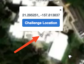
Identify the location on the map
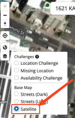
a. If you do not see a dot on the map for your address, first change the base map to Satellite
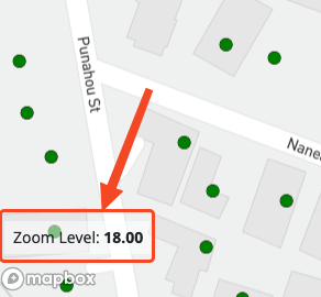
b. Double-check that your Zoom level is at 18.0
c. Click on the map to place a gray dot and then click “Challenge Location”
Fill out the challenge form
Fill out the Location Challenge form with the following information:
- Name
- Email address
- Phone number (optional)
- Address
- City
- State
- Zip
- Zip+4 (optional)
- Unit Count (if the address is an apartment, condominium, with multiple units within)
- Building Type (pick one)
- Business
- Residential
- Business and Residential
- Group Quarters – example: college residence halls, residential treatment centers, skilled nursing facilities, group homes, military barracks, prisons and worker dormitories, etc.
- Community Anchor Institution – example: hospitals, public libraries, police stations, public schools, etc.
- Enterprise – larger business with many locations and a private telecom network
- Description of why you are challenging the location (optional)**
- Supporting address documentation (optional)**
- County property tax assessment links to assist in address documentation
- Hawaii County – https://www.hawaiipropertytax.com/search.html (Link opens in a new tab)
- Honolulu County – https://www.qpublic.net/hi/honolulu/search.html (Link opens in a new tab)
- Kauai County – https://www.qpublic.net/hi/kauai/search.html (Link opens in a new tab)
- Maui County – https://qpublic.net/hi/maui/ (Link opens in a new tab)
- County property tax assessment links to assist in address documentation
- Check the checkbox to certify your information provided
**Note that supporting documentation is optional in the form, but providing evidence may increase your chance of a successful challenge
You should see the following pop-up at the top of your screen

Next Steps
After submitting a challenge, you should receive an email from BroadbandMapNotifications@fcc.gov. Please forward the email to UH broadband@hawaii.edu with your Challenge ID so we can track this challenge for you.

What to do if your location says, “Location is not broadband serviceable and does/would not subscribe to a mass market service.”
What you will need:
- A valid email address
- A document or image providing evidence of the address’ ability to subscribe to an Internet service provider such as Hawaiian Telcom or Spectrum
Verify location information
“Location is not broadband serviceable and does/would not subscribe to a mass market service.” means the map shows the address at the location would be unable to subscribe to a commercially available Internet service plan through an Internet service provider such as but not limited to, Hawaiian Telcom or Spectrum. The location may require enterprise level or a custom Internet network solution.
You can verify using the following links
- Hawaiian Telcom website: https://shop.hawaiiantel.com/cart/addressVerification/residential (Link opens in a new tab)
- Spectrum website: https://www.spectrum.com/services/hawaii (Link opens in a new tab)
Fill out the challenge form
If you believe the location is able to subscribe to commercially available Internet, fill out the location challenge form with the following information:
- Name
- Email address
- Phone number (optional)
- Building Type (pick one)
- Business
- Residential
- Business and Residential
- Group Quarters – example: college residence halls, residential treatment centers, skilled nursing facilities, group homes, military barracks, prisons, and worker dormitories, etc.
- Community Anchor Institution – example: hospitals, public libraries, police stations, public schools, etc.
- Description of why you are challenging the location (optional)**
- Supporting address documentation (optional)**
- Check the checkbox to certify your information provided
**Note that supporting documentation is optional in the form, but providing evidence may increase your chance of a successful challenge
Next Steps
After submitting a challenge, you should receive an email from BroadbandMapNotifications@fcc.gov. Please forward the email to UH broadband@hawaii.edu with your Challenge ID so we can track this challenge for you.
What to do if the information on the map is incorrect?
If you suspect any information on the map is incorrect, file a Location Challenge or Availability Challenge. Click to learn more.
Learn how to submit a challenge